Avata in Windy Locations: A Field Report From Water
Avata in Windy Locations: A Field Report From Water-Edge Flying
META: A field report on using Avata around windy reservoirs and river infrastructure, with practical notes on pre-flight cleaning, obstacle sensing, and why drone workflows matter for hydrology monitoring.
Wind changes everything at the edge of water.
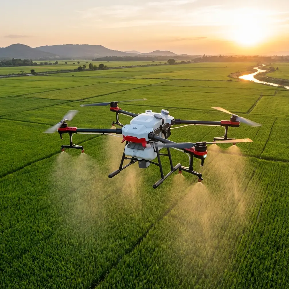
I learned that again on a dam access road before sunrise, standing above a reservoir where the gusts bounced off concrete, fencing, and the sloped embankment below. From the ground, the site looked manageable. Once airborne, it was a different story. Wind curled through the intake area, the outflow channel created its own turbulence, and the shoreline geometry produced those annoying microbursts that don’t show up in your mental picture until the aircraft is already in them.
That is exactly why the Avata conversation becomes more interesting when you stop treating it as a pure “cinematic FPV” topic and start looking at real operational environments.
For photographers, inspectors, and teams documenting water infrastructure, windy locations are not a side case. They are the job.
Why hydrology sites are harder than they look
Traditional hydrology and reservoir monitoring has often depended on people physically moving through the site: walking the perimeter, photographing reservoir buoys from dam fencing, or boarding boats to check upstream and downstream conditions. That sounds simple on paper. In practice, it is slow, narrow in coverage, and often awkward when the work area stretches across a large water body or when the shoreline itself is difficult to access.
The reference material behind this article makes that point clearly. In older workflows, survey staff used cameras, DV devices, and binoculars to inspect water facilities and patrol dam surroundings on foot or by boat. The bottleneck wasn’t just labor. It was the inability to react quickly and to see the whole situation at once.
That matters in wind because wind amplifies every weakness in a manual inspection routine. If a team has to get close to a problem area physically, gusts, spray, unstable footing, and long walking routes all slow the process. If there’s broad river pollution or a dynamic change in flow conditions, the delay between observing one section and reaching another can distort the actual picture of what’s happening.
This is where an Avata-style workflow earns attention, especially for visual documentation missions in confined or uneven terrain.
The first safety step nobody should skip
Before I even think about takeoff in a windy venue, I do one unglamorous thing first: I clean the sensors and camera surfaces.
Not because it sounds disciplined. Because it changes outcomes.
Dust, moisture residue, fine grit, and oily fingerprints can interfere with visibility and with the reliability of safety-related functions. Around dams, riverbanks, and reservoir edges, that contamination arrives fast. Mist from outflow areas, windblown sediment from service roads, and tiny droplets kicked up near the shoreline all end up on the aircraft. If you’re relying on obstacle awareness in a complex site, or trying to maintain stable framing when you’re threading between barriers, railings, or structural edges, a dirty surface is one more variable you do not need.
This becomes especially relevant when readers start asking about features like obstacle avoidance, subject tracking, QuickShots, Hyperlapse, D-Log, and ActiveTrack. In truth, windy water infrastructure sites are not the place to trust automation blindly. They are places where every assistive feature works better when the aircraft is clean, the lens is clear, and the pilot is treating automation as support rather than permission.
So yes, the pre-flight wipe matters. It is one of the least exciting steps in the workflow and one of the most useful.
What Avata changes in a windy field environment
The strongest case for using a compact immersive aircraft at water sites is not speed alone. It is speed plus perspective plus repeatability.
The source material describes how UAVs can hover in the air and provide real-time monitoring of dam intake and outflow zones, while a ground station analyzes the live aerial feed to understand dynamic operating conditions. That operational detail is more significant than it first appears.
A dam’s intake and discharge areas are exactly the sort of places where ground visibility is fragmented. Barriers block sightlines. Elevation changes create blind spots. Wind near large structures can be inconsistent from one section to the next. An airborne platform that can hold position long enough to document the scene gives the team a continuous visual record rather than a patchwork of isolated observations.
For a photographer, that translates into better coverage and fewer missed moments. For an inspection team, it means faster recognition of visible faults and environmental changes. For a training operator, it’s a lesson in disciplined flying where situational awareness matters more than raw speed.
The reference also notes a practical advantage that often gets overlooked: UAVs can reach harsh edge zones around reservoirs where manual access is inconvenient or risky. That is the kind of phrase that reads bureaucratic until you’ve actually tried to work a windy waterline. The “edge zone” is often where the best visual information lives—erosion, floating debris, shoreline discoloration, current patterns, and barriers under stress. It’s also where people least want to stand for long.
Wind, turbulence, and structural airflow
Not all windy locations are equal.
At open shoreline sites, wind can be fairly readable. At dams and water engineering structures, it usually is not. Air rolls over walls, funnels through gaps, and rebounds from hard surfaces. An aircraft can look stable in one corridor and then get bumped hard ten meters later.
This is where piloting style matters more than marketing language.
With Avata, I prefer smoother route planning and shorter, intentional passes over the high-drama “send it” mentality that people associate with FPV. If the goal is useful footage or operational documentation, a controlled hover near a feature can be far more valuable than an aggressive sweep. The source text specifically highlights the value of aerial hovering for real-time monitoring, and I agree with that emphasis. Holding position to observe intake and outflow behavior tells you more than one flashy run ever will.
That same logic applies to windy filming venues generally. If you’re capturing architecture near waterfronts, event locations by reservoirs, or industrial facilities beside rivers, your best footage often comes from understanding the airflow map of the site first. Make a conservative reconnaissance pass. Watch what the aircraft does near corners and edges. Learn where the wind shears are. Then build the creative passes.
Why live monitoring beats fragmented ground checks
One of the most practical details in the source material is the role of the ground station. It mentions that live aerial monitoring data allows operators to clearly analyze the dam’s real-time working dynamics.
That deserves more attention because it explains why drones are not just “faster cameras.”
When inspection or documentation teams rely on scattered manual observations, each image is detached from the broader spatial context. With a live feed, decisions happen while the aircraft is still in the air. You can redirect immediately, verify a suspicious area, compare upstream and downstream conditions in one session, and create a visual timeline of change.
That is operationally significant in at least two ways.
First, it reduces the lag between observation and response. If a water facility has an apparent visible fault or a surrounding environmental condition changes rapidly, the team does not need to wait for someone to return by foot or boat with images.
Second, it improves repeat inspections. If you discover a recurring issue at a fence line, spillway edge, or shoreline segment, you can revisit the exact corridor with a much shorter review cycle. The reference text explicitly points out that UAV use shortens reinspection cycles and helps update changing conditions quickly. In real field work, that means trends become visible sooner.
Avata and the reality of large-area monitoring
Large-area river and reservoir monitoring is where manual methods often break down first. The source material calls out a specific problem: broad river pollution can be difficult to monitor accurately by traditional means, especially when the work area is extensive and field investigation is slow.
Even if your immediate interest is filming rather than environmental monitoring, the lesson is the same. Coverage matters.
At water venues, conditions can stretch across a much larger footprint than your ground perspective suggests. Surface discoloration, ice movement, debris fields, shoreline stress, and access constraints rarely stay contained to one neat visual box. An airborne platform lets you capture continuity: how one section relates to the next, how the current affects visible patterns, and where the meaningful visual changes actually begin and end.
That’s one reason I like using log capture when the scene has difficult contrast. D-Log, when managed properly, can preserve more flexibility in water-heavy scenes where bright reflections and dark structural elements live in the same frame. It is not magic. It just gives you more room in post when the site lighting is punishing and the weather refuses to cooperate.
A note on automation in windy venues
People often ask whether features such as QuickShots, Hyperlapse, subject tracking, or ActiveTrack are useful around windy infrastructure sites.
My answer is simple: use them selectively, and only when the environment genuinely supports them.
In open areas with clean separation from obstacles, automated flight tools can help create repeatable motion or capture establishing sequences efficiently. But near fencing, utility structures, embankments, or complex airflow, pilot judgment should take priority. Wind at a water site is rarely uniform. It shifts around geometry, and that can turn a routine automated path into an unpredictable one.
Obstacle-related safety features are helpful, but they are not a substitute for route discipline. They work best as part of a layered approach: clean sensors, clear visual planning, conservative flight lines, strong situational awareness, and constant respect for the site’s airflow behavior.
That is especially true in training contexts. If someone is learning to fly in windy places, I’d rather see them execute a calm manual orbit and a stable hover than attempt a flashy automated sequence they don’t fully understand.
Where this becomes bigger than filming
The most compelling section of the source material, for me, is not the scenic side. It is the reminder that UAVs can provide first-hand information for difficult locations such as barrier lakes and can support faster scientific judgment by monitoring distribution and dynamic change.
That idea scales beyond one reservoir or one river corridor.
A drone like Avata, used intelligently, becomes a compact visual tool for places where people need timely, repeatable eyes on a changing environment. Reservoir edges. Dam perimeters. Upstream and downstream channels. Ice conditions on river sections. Service infrastructure in hard-to-reach terrain.
The source text also notes UAV use in aerial imaging of Yellow River ice conditions, citing advantages such as stable performance, flexible takeoff and landing, strong safety characteristics, and high timeliness. Those details matter operationally because river ice and water-control structures create exactly the kind of unstable access conditions where a mobile aircraft saves time and reduces exposure. You do not need to send people onto difficult ground just to understand what changed.
For visual professionals, there is another takeaway: industrial and environmental storytelling is richer when the aircraft is doing more than chasing cinematic angles. Some of the strongest footage comes from flights that serve an observation purpose first. The visual language becomes sharper because the mission is sharper.
My field rule for windy water sites
If I had to compress this into one rule, it would be this:
Treat the aircraft as an aerial observer first, and a style tool second.
That mindset changes how you plan every flight. You check the aircraft carefully. You clean the lens and safety surfaces. You read the wind against the structure, not just the forecast. You use hover time to study the site. You prioritize live information over dramatic motion. You capture enough context that the footage is useful even if conditions prevent the more ambitious moves.
If you’re building an Avata workflow for waterfront venues, reservoirs, dams, or river facilities and want to compare setup ideas with someone who understands these environments, you can message here for a practical discussion.
Because windy locations are rarely defeated by gear alone. They are handled by preparation, restraint, and a clear reason for every minute in the air.
And that is the real lesson from hydrology monitoring. Drone value is not abstract. It shows up where manual work becomes slow, fragmented, or unsafe; where live aerial views reveal what the ground team cannot; and where changing water conditions demand a faster visual loop than boots and boats can provide.
Avata fits that story surprisingly well.
Ready for your own Avata? Contact our team for expert consultation.